GeoJunxion and the province of North Brabant (NL) sign a three-year contract to continue to drive innovation in road safety within the TalkingMaps® initiative.
Capelle aan den IJssel, The Netherlands – 4 March 2021 – GeoJunxion and the Province of North Brabant are pleased to announce today that parties have entered into a new three-year agreement based on the Talking Maps Project. The aim of the partnership is to consolidate and improve asset management as well road safety.
The Province of North Brabant has always aimed to belong to the leading European regions in terms of knowledge and innovation, in order to provide safety and sustainability to all inhabitants. Building on decades of mapping experience, GeoJunxion focuses on high value, dynamic content that enrich environmentally conscious applications and safety in everyday life.
As such a joint pilot project between the province of North Brabant and GeoJunxion made perfect sense.
This new agreement paves the way for GeoJunxion to offer to the province its Data as a Service (DaaS). The full process of collecting information about traffic road signs by smart vision sensors can be divided in 2 stages as follows:
Data Collection
The data is based on real time information gathered by smart vision sensors installed in the road inspectors’ vehicle. The data is automatically collected as they drive their service vehicles every day.
Data Aggregation
GeoJunxion’s experienced team then aggregates the data from the various sources into a single database. GeoJunxion then compiles the data, applies its proprietary algorithm thus generating a confidence level for each data point. The confidence level conveys to which extent the traffic sign information is correct. GeoJunxion’s proprietary algorithm takes into account location, direction, sign quality and accuracy as well as statistical information.
Once validated and quality checked, GeoJunxion delivers an authoritative data set to the province every 4 weeks.
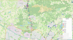
The traffic signs are highlighted in the image below, and contain meta data such as sign type, longitude, latitude as well as GeoJunxion’s confidence levels:
Thierry Jaccoud, GeoJunxion CEO commented “Our intelligent technology combined with the truth-based data collected by the Province of North Brabant enables the province to use this authoritative dataset in their initiatives to improve road safety and infrastructure for all road users. We couldn’t be prouder to be continuing that project with the innovative Province of North Brabant and support a safer world. GeoJunxion also intends to use this unique and authoritative data in its own High Alert Zones products.”
Ric Vergeer, Project Manager Infrastructure Innovations & Sustainability at the Province of North Brabant said: “This is the spin-off of the Talking Maps pilot project, that started out with a focus on ADAS assistance. But the by-product for our asset management organization is too valuable not to continue with this program of collecting “real time” data.”