Capelle aan den IJssel, the Netherlands, 14 July 2022 – GeoJunxion (GOJXN.AS) is proud to announce a partnership with the Dutch Red Cross providing a custom-made digital map to assist first-aid responders to quickly find and get to the precise location in case of an emergency at the Zwarte Cross, a 4-day Dutch festival. GeoJunxion offers its Outdoor Venue Plan custom location data service.
The Dutch Red Cross is present at the Zwarte Cross (https://www.zwartecross.nl) in Lichtenvoorde, the Netherlands. At the event, the Red Cross helps visitors in case of any medical issues. The Red Cross is present with hundreds of volunteers, to supervise an area of 2,800,000 m2 and about 220,000 visitors. This makes it the biggest Dutch event and requires a high safety standard. The Red Cross has been partnering with the Zwarte Cross for many years.
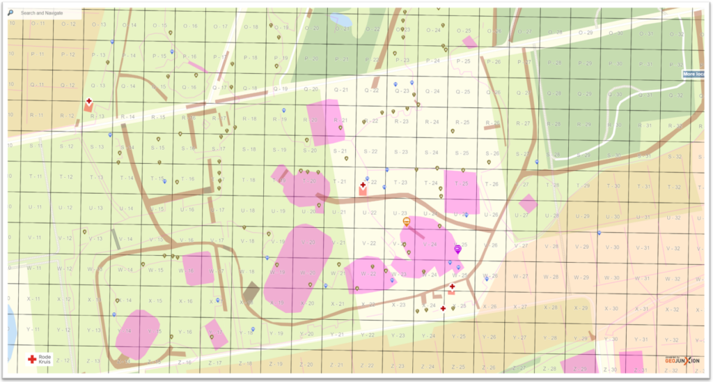
GeoJunxion developed the digital map of the area with all relevant Points of Interest (POI), such as entrances, campgrounds, stages, and all the Red Cross first aid locations. On top of the Outdoor Venue Plan of the event area, GeoJunxion created a grid to help the volunteers to identify the precise locations. In case of an emergency, the volunteers receive the grid location of the emergency place and are guided to this location on their mobile device. In this way, they can easily find and navigate to the emergency location and intervene quickly.
The Red Cross Netherlands (www.rodekruis.nl) is part of the International Federation of the Red Cross and Red Crescent Societies (www.ifrc.org/). The organization is active in the Netherlands with approximately 400 employees, about 20.000 medically trained volunteers and other tenths of thousands non-medical volunteers. With their network of generous donors, volunteers, and employees, the Red Cross shares a mission of preventing and relieving suffering, in the Netherlands and around the world. For example, they treat blisters at walking events, provide assistance in case someone needs to leave their house due to a gas leak, or provides first aid at big events and festivals.
Henk-Jan Kienhuis, one of the Red Cross members that coordinates the activities at the Zwarte Cross, commented: “We used to work with paper maps at the event to find directions. However, it takes valuable time for our Red Cross volunteers to find their own location and directions in case of an emergency. I have good connections at GeoJunxion and know their expertise with custom mapping services. Therefore, we discussed the possibility to create a custom-made digital map of the Zwarte Cross area so that the Red Cross volunteers can respond faster and more effectively to any emergency.”
Ivo Vleeschouwers, CEO at GeoJunxion: “We discussed the needs of the Red Cross with Henk-Jan Kienhuis and concluded that our Outdoor Venue Plan would perfectly meet the requirements of the Red Cross at an event such as the Zwarte Cross. GeoJunxion’s Outdoor Venue Plan are custom, fully navigable digital maps, making the experience of professionals at events user-friendly and stress-free. This applies also when the area is just a temporarily venue.”
Henk-Jan Kienhuis continues: “In case of an emergency every second counts. In the past our volunteers needed to look at the paper map, find their location and the place of the emergency. Next was to find out how to get quickest to destination. With the Outdoor Venue Plan created by GeoJunxion we now save precious minutes in response time which can be critical in case of emergency.”
Explore ZWARTE CROSS Map on PC at this link: https://www.outdoorvenueplan.com/zc_rode_kruis